[title_big title=”The Mergui Archipelago, Myanmar” /]
 The following article has been written for the 4th Edition of Sail Thailand by Adam Frost, Director of Seal Superyachts
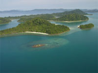
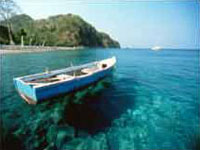
The southern islands of Myanmars’ (Burma) Mergui Archipelago lie only 180 kilometers to the north of Phuket and directly west of Ranong, Thailand’s last northwest, coastal province. There are about 800 islands opposite Myanmars’ Tennasserim coast, forming one of the last remaining untouched paradises on the planet.
These islands are densely forested and mountainous, with impenetrable jungle meeting white silica sand beaches. There are plenty of natural harbors providing a complete range of day and overnight anchorage’s for visiting yachts.
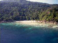
The starting point for any venture into this area is always Kaw Thoung (Cow Tong, formerly Victoria Point, and pronounced Koh Song in Thai). Tidal movement within the southern group can range up to 4 meters, creating strong currents, especially in the shallower areas and through the narrow passages. This tidal flow also causes a short, sharp chop when wind and tide are opposing. Scuba diving and snorkeling is superb with plentiful fish life and undamaged corals in all but a few of our suggested stopovers. In general, the western shores of these islands provide the best underwater topography. Visibility improves significantly west of the 98th meridian. The condition of the reefs becomes more pristine, and sightings of large pelagic fish species more prevalent, the further west you venture.
The human inhabitants of the area are a mixed race of sea nomads locally known as ‘Salones’ or ‘Mowken’. Salones have their own language and live with their extended families (dogs and cats included) onboard tarred, wooden boats. They survive on a diet of fish, sea cucumber and island game. On shore there is an abundance of fresh water, wild animals and reptiles to help sustain them. They are the real “Sea Gypsies” of the archipelago, preferring not to live ashore but constantly move from island to island within the group. The ‘Mowken’ are neither inquisitive nor afraid and prefer to be left alone.
 Animal and bird life is prolific on the islands. Although impenetrable jungle prevents sighting of larger mammals, their tracks are plentiful above the high tide mark on the beaches of larger islands. Macaque (pronounced ma-cak) monkeys and large monitor lizards are seen frequently on the beaches and rocky shorelines. Monkeys visit the shoreline at low tide to feed on crabs, eating the sweet meat under the shell and discarding the rest to the sea. The larger islands are believed to support a wide variety of mammals and reptiles within the dense rain forests, although no formal study has been done since the turn of the century. Crocodiles have been seen, and there has even been a suggestion that the rare Asian rhinoceros might still survive on the larger islands. There are literally hundreds of anchorage’s in this southern Mergui group.
Sailing Permits and Checking in to Myanmar
All activities within the Mergui Archipelago fall under the direct control of the divisional commander of the Tennasserim province. This province covers the towns of Miyak, Bokpyin & Kaw Thoung. Licenses pertaining to the operations of charter companies operating within the Archipelago are issued in Yangon by the Ministry of Hotels & Tourism. The every day operations within the Mergui Archipelago, are closely monitored by the divisional commander & the area commander.
All of the charter companies running diving or sailing trips out to the Mergui Archipelago, work hand in hand with Myanmar Travels & Tours (MTT), Kaw Thoung branch. All passengers’ who join trips, out to the islands must pay a set entry fee. This fee is dictated by MTT. It is presently US$120 per person but can change without notice. This money goes partly to the local administration in Kaw Thoung and partly to the Government in Yangon. There is also a fee of US$18 per person that is payable to Kaw Thoung Immigration. This will give each individual a permitted stay of up to twenty-eight days in Myanmar.
It is not possible for a private yacht just to arrive in Kaw Thoung, obtain a permit from Myanmar Travel & Tours and go cruising in the Archipelago. It is however, possible for a yacht that wishes to go cruising in the Mergui Archipelago to obtain permission to enter and cruise the region under the umbrella of one of the charter companies, licensed to operate in the region. These permits do not come cheap, as special permission must be sought, for each individual vessel’s application. The heavy cost of such a permit makes it prohibitive to the average yachtsman. The days of just un-monitored do as you please kind of cruising, as is the case in Thailand is still a long way off, if ever! The government keeps very strict control on activities in the Mergui Archipelago.
Myanmar Travel & Tours also demand that each vessel must have a government appointed guide to join on every trip out to the Archipelago. The guide makes a full record of the vessel’s activities whilst out in the Archipelago. This record is then submitted to the local authorities on return to Kaw Thoung for their review.
 The military have camps and roving patrols on most of the Islands in the Archipelago. Vessels’ progress is monitored out in the Islands. The military are in radio contact with each other. Some Islands are strictly off limits to all vessels due to army bases and military installations. These Islands are made clear to all charter companies operating in the Mergui Archipelago. The Navy operates a fair number of smaller patrol craft in the region. They regularly make checks on all vessels including dive boats, sailing yachts and fishing trawlers. Illegal fishing (including Dynamite fishing) and illegal logging is their main concern. Anti-government forces are still occasionally found hiding out amongst the Islands!
It would be pure folly to enter without the proper approvals and permits. Although the official requirements may appear daunting, the unspoiled, remote-from-it-all cruising to be enjoyed here is well worth the effort and cost.
Ranong and Kaw Thong (Victoria Point)
Vessels that have already cleared Thailand and have the necessary pre-arranged permit to enter the Mergui Archipelago can go directly to the anchorage at Kaw Thaung. Vessels that have not cleared Thai waters should first anchor on the Thai side of the Pakchan River and clear the vessel in Ranong town (or alternatively clear the vessel out, in Phuket before arrival). The busy Thai border town of Ranong is a major fishing port that attracts all the frantic activities of a frontier settlement. There are two jetties for dinghy landings (or hail a long-tail), giving access to taxi transport.
There are two Thai Immigration departments. Foreigners are expected to use the official Immigration office, which is situated 300 meters from the fishing jetty, on the main road to Ranong Town. It is open from 8:00 am to 6:00 pm. The other Immigration office is situated on the northern river approach to and from Kaw Thoung. The main purpose of this office is to check the local Thais and Burmese going back and forth over the border. Clearances completed proceed to the Burmese side at Kaw Thoung.
The check-in point for all foreign vessels entering the Mergui Archipelago is at the Customs and Immigration post at Kaw Thoung, formally known as Victoria Point, or Koh Song in Thai. Good holding can be found in 4 to 6 meters on a muddy bottom between the southern point and Browning Island (Mwe Is.), directly east of the town. Be warned that strong currents are prevalent in this channel. There is also a very high risk of being rammed by long-tail boats and fishing trawlers! Go ashore via the floating dock extending from the south end of the harbor to visit this thriving border town. Kaw Thoung is a real treat, with cheap and interesting shopping and plenty of action along the waterfront. Climb the hill at the south end of town to see the memorial site and excellent views overlooking the Pakchan River and the islands of both countries.
 The island just south is Pulau Rau (Thu Htay Kyunn). Anchor on a muddy bottom off the hotel jetty on the East Side in 8-11 metres. This island has been tastefully developed to accommodate ‘The Andaman Club’. This 5-star hotel and casino is accessed from the Andaman Clubs’ private jetty on the Thai side of the Pakchan River, just west of Ranong. Security is tight and access ashore is by prior arrangement only. The hotel is superb with a kid’s video arcade, immigration office, cable TV, pools and of course, huge gaming and VIP rooms with foreign croupiers at most tables.
Due to recent conflicts between Thai and Burmese fisherman, all cruising in the Mergui Archipelago is now restricted to North of 10.11.00 N Degrees Latitude. The Islands of Hastings & Saint Matthews are off limits due to military bases in the region. This means that a passage of approximately forty nautical miles must be traveled after departing Kaw Thoung, to arrive at the first of many great anchorages in the Mergui Archipelago.
Navigational note: Local fishing boats (long tails) do not generally use lights at night. They will normally use a flashlight or lantern when approached. This makes navigation through the islands quite tricky. A good bow watch is highly recommended. There is an additional hazard when sailing through the strait of water that separates the main land and St Matthews Island at night. This is the presence of large circular fishing traps made up of wood, bamboo and net. They are generally in the shallower waters but can create a real hazard for the unwary. They are unlit at night and are extremely difficult to detect by radar.
Cavern Island (Hlaing Gu Island) 10.18.5 N 97.59.00 E
Moving further west in to the archipelago the water not only gets deeper but also clearer. Cavern Island is aptly named as on the southern end of the Island there are indeed several large caverns or caves on the water line, one of which is large enough to drive a small vessel in to. Moving slightly west from the caves is a nice little cove, which has a good anchorage. Going ashore here one will find a fresh water stream. This is used by the local fisherman and Moken to replenish their fresh water supplies.
Stewart Island (Bo Wei Isl.) 10.21.00 N 97.57.50 E
North west of Cavern Island is Stewart Island. The island is very good for Scuba diving. Especially the small island on the Southern end which above water has a large hole in it, making it quite spectacular to look at. Diving here is exciting, as there are several good size swim throughs, which are packed with schooling fish, especially red and white Snapper. Black tip and white tip Sharks can be found patrolling the sandy bottom at a depth of around 20 m. Good size lobsters are common at this dive site.
Swinton Island (Khun Phi Lar) 10.33.00 N 97.57.00 E
North of Loughborough passage (Jar Lann Passage) is Great Swinton Island. This anchorage provides good holding in winds up to 20 knots in both seasons. Enter the bay, favouring port to avoid the drying reef and anchor in 11-15 metres close to the middle of the bay on a sandy bottom. A fresh water creek ashore, has cleared a small passage in the fringing reef. This is ideal for dinghy and small craft access to the low-lying beach ashore. There is great snorkeling around the reef edge.
Lampi Group (Kyunn Tann Shey)
The West Coast Of Lampi
It is possible to anchor anywhere off the western coast of Lampi Island. Lampi is the largest island in this southern group and is largely uninhabited. Our favorite spot is the southwestern beach, behind the small island near the mouth of the sandy mangrove tidal river. Anchor anywhere on sand in 6-12 metres. The Mangrove River offers superb dinghy exploring with plenty of wildlife and huge, century-old mangrove trees towering overhead. On the south side of the river is a rocky wall ideal for shallow snorkeling. There’s a small underwater cave complete with mangrove jack and baitfish.
Salet Galet 10.53.00 N 98.05.00E
The channel of water separating the islands of Lampi and Wa-Ale Kyun is about 150 Meters wide and two miles long. Either side of the channel is banked with steep sloping rainforest and by fringing coral reef below. It is a very protected piece of water and of outstanding beauty. Anchorage in the middle of the channel in 10-15 meters of water is ideal. This anchorage is safe to sit out any storm!
It is a good place to spot Monkeys, wild pigs, hornbills, sea eagles and other creatures of the Archipelago.
Pu Nala ( Bo Cho ) 10.41.00 N 98.16.00 E
Enter the passage either side of the small Rock Island and south of the drying rock in mid channel. Anchor in 4-7 metres on a muddy bottom. The currents can run up to 3 knots at mid tide, so try to plan around this for easier anchoring. Put out plenty of chain to hold opposite the small village on the north of Pu Nala. This village is the only habitation in this area and is definitely worth a visit. The local monk at the Buddhist temple welcomes all, and educational gifts of pencils, pens, exercise pads and sweets are a favorite with the children. Take your cameras, as these scenes may astonish even the most experienced traveler.
Clara Island ( Kyunn Me Gyee ) 10.53.00 N 97.53.50 E
Anchor in 12-15 metres on a sandy bottom off the fringing reef in the south bay. This anchorage is the only option for this majestic island and it does not disappoint. There are 3 sandy beaches ashore, and the snorkelling and diving are excellent. Both south and north Sentinels are also excellent stops for diving, fishing and snorkeling.
Mid Group
The islands south of Lampi and Pu Nala offer plenty of day and overnight options for stop- offs. We have chosen just two of the prettiest spots in this group, although you can spend days here exploring all the smaller rocky islands and hidden coves and beaches.
115 (Frost Island) 10.28.00 N 98.10.50 E
The Frost brothers of SEAL (South East Asia Liveaboards), the pioneers of cruising this area, discovered this jewel anchorage. This is the usual, first-night-out anchorage stop on their cruises. Anchor in 12-15 metres off the white sand beach. The all-tide, sandy beach here is breathtaking, and the fringing coral reef provides excellent snorkeling
Pulau Labiaung (Linn Shu Island) 10.37.00 N 98.14.50 E
A fairly small island but is notable for it’s beach on the eastern side of the Island. A very nice sandy spit which is great for general beach visits and swimming. Be warned that a good current sets just off the shore here. Access to the beach is tricky from the East, as there are several submerged rocks, which are not shown on the charts for the area.
Dommel Island (Pan Daung Island) – West Coast.
Anakena Bay 11.33.00 N 98.12 E.
A beautiful deep bay, with gradual sloping sandy bottom. Good anchorage within 200 meters of the beach, in a depth of 8 meters. The beach is approximately one kilometer long. On the southern end of the beach is a very nice tidal inlet, which at low tide is walkable. On a high tide it is possible to travel up to four kilometers inland using a tender. This is a good area for bird watching. Resident birds in this area include Great hornbill, Green hanging parrot, sandpipers, cuckoo, Basra and red wattled lapwing.
According to local fishermen who have lived in this are for the last ten years, there is an abundance of wild boar and buffalo living in the forest.
Antarctica Bay – WSW of Aveline Hill 11.39.00 N 98.14.00 E
Another stunning bay on the West Coast of Dommel Island. Great anchorage, the bay encapsulates three pristine beaches with a small headland separating the southern two. Good holding can be found in a depth of about fifteen meters off the northern most of the three beaches. There is a small fresh water river on this beach, good bird watching here, some resident birds in this area include, the Chinese pond heron, Black capped Kingfisher, wreathed horn bill and the Asian brown fly catcher.
Pearl Farm – SW Bay of Dommel Island
A Japanese/Burmese joint venture is based in the bay on the South West of Dommel Island. Large areas of floating pearl nets protrude up to half a nautical mile off shore, which could cause a navigational hazard at night. Patrol craft will challenge any visitor to this area. A large camp is situated on the Southern most of the beaches in the bay. The pearl farm should not be visited without organizing a special permit in advance.
Yanakee Bay – Southern Tip 11.25.50 N 98.13.00 E
At low tide, the main beach in this protected bay dries out to an area roughly equivalent in size to four football pitches. On the right hand side of the beach is a salt-water estuary. If visited just before sunset or very early morning you are virtually guaranteed of seeing large numbers of Wreathed Hornbills, flocks of up to twenty birds are not uncommon. Nesting red wattled Lapwing are also resident here, their noisy alarm will warn all of any unwanted visitors.
Down on the waters edge at low tide it is possible to collect a pot full of fresh butter Clams, for only ten or fifteen minutes effort.
Kar Mar Island – (Kar Mar Bay) 11.11.00 N 98.15.00 E
One of the most stunning beaches in the whole of the Mergui Archipelago. There is a good Anchorage at the southern end of the bay. A depth of ten meters, within 100 meters of the shore. Halfway along the beach is an old shipwreck, it’s stark white hull stands clear against the backdrop of green jungle behind the beach.
Travelling further south along the coast there is another smaller bay with two nice beaches.
It should be noted that both Ka Mar Island and Pa Lei Kyunn Island are both off limits due to a naval/army base of Pa Lei Kyunn. On the South east of Kar Mar Island is another Navy base. This one has a small jetty
Elphinestone Island – Thayawthadadanyi Kyun
Port Maria (North Bay) 98.02.00 N 12.22.00 E
Not the most picturesque of anchorages although it provides good shelter from the Southwest monsoon. On the western coast of the bay there are two reasonable beaches with quite good holding within about one hundred meters of the shore. The beach on the south coast of the bay has a small fishing village on the eastern end of it and a small army camp on the other. Visitors are welcome ashore here.
There is a nice tidal inlet in the southwestern corner of Port Maria. This is navigable for about two kilometers until the inlet forks to two distinct channels. A good place for bird watching.
Hetarious Bay 12.21.20 N 97.57.71 E
This is a long deep bay, a good protected anchorage with a gently sloping bottom. There are a few small beaches set a round the bay. It is a perfect night anchorage in the NorthEast monsoon.
Historical Mergui Town
 Very few western tourists have traveled to Mergui in the last thirty years. As it had been closed off by the Myanmar government. The town itself has a great feel about it. With a rich maritime history stretching back over four hundred years there are many interesting places of historical interest to visit.
The population of Mergui is a real melting pot. A big Indian and Arabic influence is noticeable in a large percentage of the locals, especially the port workers and laborers. The largest contingent is still of course the local indigenous Burmese. A fusion of different nationalities through the centuries has given the town a very cosmopolitan feel about it.
There is also a large Chinese contingent, whose main sector is just north of the main Market Square. The architecture is typically Chinese. A visit here will see many little engineering workshops with work in progress sprawled out from the basement level style garage and out on to the pavement. Engine blocks, pumps and other assorted mechanical hardware is all there in various states of disrepair. To the glimpsing eye it looks like a scene of total unorganized mayhem. But to the shopkeeper I’m sure it is all under control. Now where did I put that wrench?
The Chinese also seem to be running all the local hardware stores in the town. Goods on display in the shop frontage range from fishing nets and floats to plastic hose, rubber boots buckets and shovels. In fact basically anything your local fisherman or building contractor could ever need seems to be in stock.
The local market is a sight to behold. The whole market area is under cover in a permanent single story one-room building, with about fifty entry and exit points. Total area must be about one square kilometer. On entry, first impression is of an Indian style bizarre. Lots of alleyways run parallel and perpendicular to each other. Either side of these alleys is crammed packed with individual stools, with their owners perched on raised platforms at waist level, selling their wares. It is quite easy to become disorientated whilst browsing. Once the day’s selling is finished the market is closed and locked with antique wooden louvered doors, barring all entry points.
All sorts of interesting things are for sale here. Most types of produce seem to be grouped together in different areas of the market. Clothing for example is all grouped in one alleyway as are electrical goods and house hold items in another. All electrical appliances are counterfeits of the better known Japanese brands.
The meat market is reminiscent of medieval times. Having a smell all of its own. A strong stomach is needed, to browse here. Whilst out shopping with the ship’s cook, I watched an old lady cleaning pigs intestines scraping the innards out with a flat knife and depositing the remaining intestine in a nice pile for sale. Obviously for those who wish to make their own sausages. Or maybe a nice intestine broth! On the stall next door, a lady was shaving the hairs of an odd looking piece of meat with an old Wilkinson style razor blade. After a few seconds of study I realized it was the pigs nose. Other weird and wonderful sights were to behold here but I felt they should be saved for another time.
Walking around the outer perimeter of the market complex. There is a small congregation of local goldsmith shops. Each with a small display case full of rings, pendants and chains. Directly behind the display counter and sales girls are the Goldsmiths at work, plying their trade with blowtorch, various forming tools and instruments. The end product is not of a genuinely high quality but it is well worth ten minutes or so to watch these tradesmen at work.
To sum it up, Mergui Town really is one of the jewels in the crown of the beautiful Mergui Archipelago!
Approaches to Mergui Port
There are two different routes that may be taken to navigate safely in to the Port of Mergui. The first is from the North through the IRON PASSAGE, between Thamihla Kyun and Kadan Kyun (King Island). There is good depth of water through the passage. Although there can be strong currents. For smaller craft, it would be advisable to keep a look out for strong eddies.
Traveling South after navigating the passage is pretty straight forward until you come to the navigational light (F1.8 m) at the Northern approaches to Mergui Port. The light is a significant structure and can been seen quite clearly.
Passage into the port should be to the west of the light. A distance of about 100 – 150 meters from the light is safe. The waters are shallow. There are mud flats that dry at low tide further to the west of the light. Depth of water is less than 2.6 m at low tide on springs so it is advisable to go in on half tide or more just to be safe (this area is known as the Mergui bar). The port will be visible at this point.
There is another navigational light, which is in the town, but can be hard to see. Depth of water will remain constant until reaching the anchored vessels in front of the town. The best anchorage is to be found slightly South of the town, directly in front of the large reclining Buddha image on Pataw Island. Depth of water is approximately 15 meters. Holding is good, but strong currents prevail. Boat traffic is a little less here too.